Entrance to Baños from the Bus Terminal
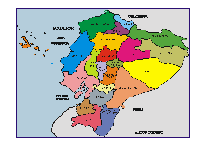
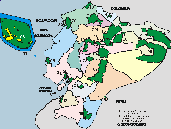
Baños - Tungurahua Province
Baños de Agua Santa
Baños has a temperate climate with an average temperature of 18ºC, and is located at an altitude of 1,820 meters above sea level. on the slopes of the Tungurahua volcano.
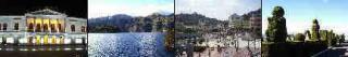
Turismo en Baños
Turismo en Baños
Baños de Agua Santa
(Baños de la Virgen del Agua Santa)
Baños is also known as "La Puerta del Dorado" and offers many attractions: you can rest in the thermal pools, you can visit the Basilica de la Reina del Rosario de Agua Santa, you can visit the different waterfalls, you can climb the volcano Tungurahua, you can try the melcoches (sugar cane honey sweets), there are varieties of balsa and tagua crafts.
GR

OTHER INTERESTING SITES
- City of flowers and fruits, also known as the city of the "three Juanes", and the capital of the Tungurahua province. Typical foods are "llapingachos", guinea pigs and in November the famous "colada morada". (45 min. from Baños with the interprovincial buses)
Piscinas de aguas termales
- The Piscinas de la Virgen are located in the center-east of Baños below the Cascada de la Virgen del Agua Santa. They have hot springs of volcanic origin.
- This volcano is active and has been erupting since 2001. It has a height of 5,023 meters above sea level and is accessible from the city of Baños. The active volcanoes Tungurahua and Sangay 5,230 masl are within the Sangay National Park. There are different travel agencies and professional guides that offer their professional mountaineering services.
Baños offers the service of national and international hotels, restaurants and bars.
Baños, due to its location in the center of the country, its mild climate and its tourist attractions, is the ideal place to rest in a quiet environment, and for excursions and trips to nearby sites and attractions.
La Basílica de la Reina del Rosario de Agua Santa
- Also known as "The Sanctuary". It has different paintings inside and an interesting museum.
- Las Piscinas El Salado They are located a little outside the center (15 minutes on foot), you can use the urban bus to El Salado. They have hot springs of volcanic origin.
.
- Las Piscinas Modernas They are located near the Piscinas de la Virgen on Calle Martínez. They have hot springs of volcanic origin.
- Las Piscinas Agua de la Vida They have warm water.
- Las Piscinas de Santa Clara They have warm water and are located at the end of Santa Clara street.
- Most hotels have warm water pools.Most hotels have warm water pools.
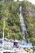
- La Cascada de Río Verde, or the Pailón del Diablo is located 20 km from Baños. Here the Río Verde forms an impressive waterfall inside the rocks.
Las Cascadas
- La Cascada de la Virgen del Agua Santa is in plain sight in Baños.
- La Cascada Inés María (Río Pastaza) is located approximately 1 km from the center, passing the San Martín Bridge near the Zoo on the road to Lligua.
- La Cascada de Agoyán It is an impressive waterfall 5 km from Baños (Río Pastaza), but for reasons that use the water for hydroelectric generation, it does not always carry water. You can use the urban bus to visit it.
- La Cascada El Manto de la Novia It is located 12 km from Baños, before Río Verde. There is an impressive tarabita on the river. It can be reached by bicycle or bus.
- The next big city was to the East, capital of the Pastaza Province. To travel to Puyo, you can rent mountain bikes, visit some of the waterfalls on the way and get to Puyo. (60 min. from Baños with interprovincial buses)
Salasaca
- Crafts Fair of the Salasaca Indians: Manufacture of wool items such as tapestries, bags, caps and paintings. Fairs on Saturdays. (15 min. from Baños with interprovincial buses)


Other destinations, cities and sites