Tourism in the
Province of Tungurahua
Tourism in Tungurahua
Tourism in Tungurahua
GR
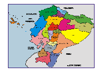
The Province of Tungurahua has an area of 3,336 square kilometers, and is divided into 9 cantons. The province was created on May 21, 1861, and independence was celebrated on November 12, 1820.
The Festival of Flowers and Fruits of Ambato is famous, the different Carnival festivities in the cantons and the city of Baños offers hot springs, access to the Tungurahua volcano and the Golden Orient.
MUNICIPALITIES / CANTONS
- City of flowers and fruits, also known as the city of the "Tres Juanes", and the capital of the Tungurahua province. Typical foods are "llapingachos", guinea pigs and in November the famous "colada morada".
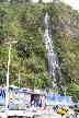
- One of the most visited sites in the Ecuadorian highlands (average temperate climate 18 ´C) also known as "La Puerta del Dorado" with its attractions: the thermal pools, the Basilica of the Queen of the Rosary of Agua Santa, the different waterfalls, the Tungurahua volcano, marshmallows, handicrafts, national and international hotels, bars and restaurants, etc. (35 min. from Ambato with buses to Baños and Puyo)
Cevallos
- City of fruit trees, also known as "the land of apples"
Mocha
- Mocha is famous for its bulls, which participate in many bullfights in the area.
Patate
- Ciudad de producción de frutas y vinos. Interesante es consagrado al Señor del Terremoto y un plato típico son las "arepas de zapallo. (en bus a 30 min. de Ambato)
Pelileo
- Today known as the "City of Jeans" for the manufacture and sale of jean articles. (15 min. from Ambato with the buses to Pelileo and Baños)
Píllaro
- Known for the manufacture and sale of leather goods such as sweaters, jackets and shoes. In August it is worth visiting the bullfight. (by bus 30 min. from Ambato)
Quero
- Since you can see (especially at night) the Tungurahua volcano in eruption.
Tisaleo
- It is a small town near Ambato.
OTHER INTERESTING SITES
Salasaca
- Salasaca indigenous crafts fair: Manufacture of wool items such as tapestries, bags, caps and paintings. Fairs on Saturdays. (15 min. from Ambato with the buses to Pelileo and Baños)
- Manufacture and marketing of leather goods such as sweaters, jackets and shoes. (by bus 30 min. from Ambato)
Pinllo
- Known for "The famous Pinllo bread" and its typical dishes of "Gallinas de Pinllo". (15 min. from Ambato with the buses to Pinllo)
- This volcano is active and has been erupting since 2001. It has a height of 5,023 meters above sea level and is accessible from the city of Baños. The active volcanoes Tungurahua and Sangay 5,230 masl are within the Sangay National Park.
El Carihuayrazo
- It has an elevation of 5,020 meters above sea level. and it is a stratovolcano without activity in historical times. It is located 22 km from Ambato.
Los Llanganates
- The Llanganates mountain range is part of the Llanganates National Park. It is here, where it is presumed that gold is hidden in the Rumiñahui treasure. One of the famous sites is the Pisayambo Lagoon. To enter the Llanganates National Park it is suggested to hire a professional guide.
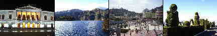
The Cathedral of Ambato - Tungurahua Province


Other cities and sites
Other provinces
Imbabura - Loja - Los Rios - Manabi - Morona Santiago - Napo - Orellana - Pastaza - Pichincha - Santa Elena
GOBIERNO DE LA PROVINCIA TUNGURAHUA
Teléfono: (593) 3- 2820311, 2823051
CAMARA DE TURISMO DE LA PROVINCIA
Teléfono: (593) 3- 2822149